Our Technology
Turn information into game-changing insight.
CTEH utilizes custom software and cutting-edge solutions to help simplify data and project management, streamline analytics, and improve decision-making.

See Operations Clearly
Things change quickly on a project site. Whether you have scheduled updates to your facility or emergency demolition and reconstruction following a disaster, mapping progress is a game-changer for project management and reporting. CTEH can help you implement advanced systems to more closely track operations—to track progress, follow status over time, and maximize efficiency.
-
Monitor Incremental Changes
Our aerial drones and robot dogs are powerful tools on their own, but enhanced with AI programming they become invaluable partners. Through continuously scheduled missions, they can monitor and catch unexpected impacts that personnel might not notice for days or weeks—making possible to alert your team of color changes on colorimetric or acid-reactive tape, and paint or draw attention to wilting or dying plant life in a release area.
-
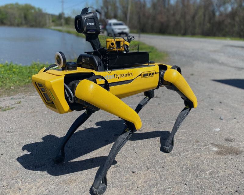
Reduce Risk With Robots
SPOT robot dogs and UAVs can perform entries and assessments—limiting employee exposure to possible toxins and keeping them from going into high-risk situations without enough information. SPOT can be programmed to patrol an area and take photos that create a digital twin of your site, greatly simplifying the process of seeing the extent of damage and progress of repairs over time. UAVs give an overview of impacts easily missed at ground level, which can be combined with AI analysis of visual changes to soil and plant life.
-
Accurately Map Sites
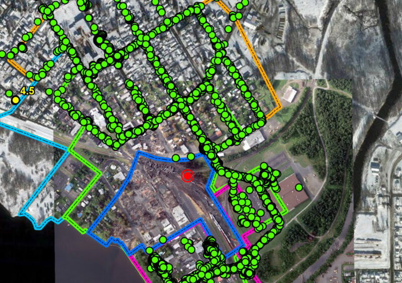
CTEH’s in-house geographic information system (GIS) expertise enables us to quickly incorporate visual updates into the operational plan as new information arises. These capabilities are enhanced with services such as BlackSky, allowing us to seamlessly integrate new satellite imagery with our on-site aerials. The result? Visually mapping and monitoring flooding, liquid chemical releases, and fires has never been easier.

Deploy Data-Driven Insights
CTEH makes it possible—and practical—to empower your operations team with comprehensive, quality-driven data collection, sophisticated visualization tools, and advanced modeling solutions for predictive analytics.
-
Integrate Your Data Management
At CTEH, data handling and management is not just an afterthought or add-on service. We proactively centralize and manage data from the very start of every project, so stakeholders can monitor conditions in real-time, at all times. Our solutions include dashboard visualization tools that help you make data-driven decisions quickly. In addition, on-site data managers can perform quality assurance and quality control live, with direct access to CTEH field staff.
-
Harness Advanced Air Quality Modeling
With CTEH data solutions, you can conduct comprehensive air quality modeling to predict and monitor environmental impacts. The key is that models are only as accurate as the data fed into them; the CTEH approach allows models to be continually updated with field data to help ensure you can generate accurate insights into current and future outcomes.
The CTEH air quality and atmospheric dispersion modeling teams assist clients with site safety, situational awareness, and community exposure evaluations. We construct informed models to help identify any impact and movement of chemical releases and assist in determining:
- Areas of impact to community, site, or facility
- Safe work zone delineations
- Real-time plume variation from changing meteorological conditions
-
Enhance Communication in Challenging Places
Projects and work sites requiring environmental analysis and remediation are often in remote locations with poor cell reception and no internet access—which presents both safety and operational challenges. We’re ready to take them on. Not only does CTEH operate on the FirstNet responder network for enhanced cellular access in disaster areas, we also mobilize portable cell towers to improve site communication. In even more-remote environments, we deploy mobile satellite internet through a dedicated trailer or as part of our mobile command center.

Custom Tech Tailored to Your Needs
Off-the-shelf technology systems can’t give you the flexibility to respond effectively to challenging or unforeseen scenarios. If the software for your problem does not exist, we are here to help. CTEH has experienced in-house full-time software development, robotics, and data management teams with an emergency response mindset. We build custom tools to manage your process or project at emergency response speeds, getting your unique project online in days, not months.
Our approach integrates technology and quality into every aspect of the project management process: gathering, integrating, analyzing, and presenting data to stakeholders in the most efficient, accurate and understandable way.
-
Craft New Solutions for Emerging Problems
Our developers build custom process management and project management tools for large enterprises, government programs, and single-event projects. We deliver full-cycle process management SaaS solutions, from feature planning to production and support. CTEH is uniquely talented at developing solutions for new or one-of-a-kind problems, and integrating them seamlessly with your existing tools. You tell us your problem; we supply a custom solution to address it head on.
-
Carbon Process Management Platform
Carbon Process Management Platform – Carbon, for short – is our in-house low-code platform. Carbon is entirely configurable and modular to fit any process, project, or program. Utilizing Carbon’s base framework, we are able to rapidly design and implement systems that precisely fit your unique use case.
The Carbon Process Management Platform has hosted and managed several large government programs, many corporate client systems, and project-specific process management tools. Some examples include:
The CTEH software solution you are most likely to identify in our materials is CarbonCM. Following the series of hurricanes in the 2016 – 2018 seasons, CarbonCM was utilized across several states to manage recovery efforts from major rebuild and rehabilitation programs. Our most exciting achievement was becoming the official management software for the Texas General Land Office’s FEMA-funded Direct Assistance Limited Home Repair (DALHR) program. Our flexibility allowed us to manage integrations with the GLO’s damage assessment contractor and the State’s invoicing system both, meaning the GLO staff, supplemented by CTEH employees, were able to manage the full lifecycle of a survivor’s housing journey from application to contractor payment to warranty repairs.
In the early days of the pandemic, a number of our customers were scrambling to identify and adopt methods of guest registration, employee wellness & temperature checks, and, eventually, test verification and management. Our CTEH development team and data managers were quickly able to build, from the ground up, a wellness process and test management database. Personnel and guests were able to be registered, sent daily wellness reports, track temperature checks and wellness verifications at the door/gate, integrate or accept manual upload of Covid tests, and track vaccination status. All of the information was captured, quality control verified, and reported to qualified individuals in digestible formats, allowing for quality decision making on behalf of the company. During the pandemic, CTEH built and managed versions of this software for dozens of companies, hundreds of live events and productions, and tens of thousands of workers.
Once the vaccine rollout began, many companies continued to wrestle with the logistics and health data privacy implications of receiving, reviewing, and storing proof of testing and vaccination as they returned to work or implemented this strategy to safely resume live event attendance. CTEH was able to develop a sister system to Test Management devoted to this process. Vaccine cards and tests were received and validated by HIPAA and epidemiologist-trained individuals to confirm if attendees or workers met vaccination and/or testing requirements outlined by public health agencies and event venues. The verification process provided attendees peace of mind with this simple front-facing system where at the end they were able to show a green screen of approval to gate checkers for entry.
As the avian influenza epidemic ravaged poultry producers in the American midwest in 2015 and 2016, CTEH was tasked with tracking and validating equipment, personnel, capacity, and process management, among other tasks by USDA APHIS, which had ultimate responsibility over the multi-state response. Our team built out a multi-module tracking and badging system in which every piece of equipment and personnel working on the farms were registered and checked on-site multiple times per day. This system empowered APHIS to manage logistics across a massive footprint: underutilized resources could now be identified and shuffled to farms in need. Finally, the pinpoint accurate reporting generated by the rigorous registration and check-in process helped APHIS to rectify incorrect billings across the life of the project, directly benefiting taxpayers to the tune of over $100 million USD.
-
Moisture Assessment Survey Tool – MAST
MAST, our proprietary moisture mapping and restoration support software, revolutionizes on-site data collection and reporting, providing you with enhanced efficiency and improved decision-making capabilities throughout the restoration process.
We provide ongoing data support and defense, analyzing and interpreting the information we gather. With our robust documentation, you can confidently validate your work and demonstrate your value to your clients.


Shawn Nelezen
Senior Vice President, Montrose Environmental Group, Inc.
The CTEH data team’s innovative database solution is revolutionizing our processes, enhancing efficiency and accuracy while significantly reducing cycle time. We’re setting a new industry standard for data collection and document automation.”
Recent Articles